Vistas - Kaskasvagge - Tarfala: Experience needed

Hej,
I need some help!
Starting mid of August we intend to walk from Nikkaluokta via Vistasstugan to Kaskasvagge, turn south after the bridge, pass Tarfala glacier in the east and then over Tarfalaryggen down to Tarfala following the way marked in Fjällkartan. My questions are:
1. Should we prefer the vad south of Vistasstugan or should we take the bridge?
2. What about tent pitches and water between Tarfala glacier and Tarfalaryggen?
3. What is the grade of difficulty compared to the two-pass route via Kuopervagge along the glacier down to Tarfala?
Is somebody experienced and can give me some hints? Any response is appreciated.

Kind regards

Christian
 
Hej,
I need some help!
Starting mid of August we intend to walk from Nikkaluokta via Vistasstugan to Kaskasvagge, turn south after the bridge, pass Tarfala glacier in the east and then over Tarfalaryggen down to Tarfala following the way marked in Fjällkartan. My questions are:
1. Should we prefer the vad south of Vistasstugan or should we take the bridge?
2. What about tent pitches and water between Tarfala glacier and Tarfalaryggen?
3. What is the grade of difficulty compared to the two-pass route via Kuopervagge along the glacier down to Tarfala?
Is somebody experienced and can give me some hints? Any response is appreciated.

Kind regards

Christian
1. Take the bridge!
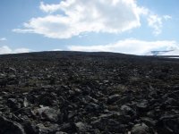
2. I don't have Tarafalaryggen on my map so I'm not 100% sure I answer for the right spot, but the all the way from Kaskassavagge to Tarfala there are like a million rocks, and no really good tent spots.
3. I would say this way is a little easier than the one along the glacier from Koupervagge. Last part i steep, but els it is mostly lots and lots of rocks and some elevation.
 

Bilagor

  • 22008548748_a1d222f333_o.jpg
    22008548748_a1d222f333_o.jpg
    49.9 KB · Visningar: 697
Månadens produkt: Trangia Nest
De nya tallrikarna, skålarna och muggarna packas smidigt och kompakt ihop med Trangias klassiska kök. Ta chansen att vinna och testa serien!
Hello,

I (and many others) have taken that path, so let me try and help (and I saw camlun answered too....)

1. I usually take the bridge, it's only a few hundred meters extra. But if water levels are not high, fording is probably not difficult.
2. Once you have climbed up south of the Kaskavagge shelter the ground is very stony, but when you come higher up towards the glacier there is good ground for tenting, and water shouldn't be a problem. It is quite high so can be rough in bad weather.
3. About the same. Orientation may be a bit more difficult on the plateau below Tarfalaryggen if the weather is bad. Bring a compass.

Enjoy! If the weather is good the stretch between Kaskavagge and Tarfala is one of the greatest in Lapplandsfjällen.

Hej,
I need some help!
Starting mid of August we intend to walk from Nikkaluokta via Vistasstugan to Kaskasvagge, turn south after the bridge, pass Tarfala glacier in the east and then over Tarfalaryggen down to Tarfala following the way marked in Fjällkartan. My questions are:
1. Should we prefer the vad south of Vistasstugan or should we take the bridge?
2. What about tent pitches and water between Tarfala glacier and Tarfalaryggen?
3. What is the grade of difficulty compared to the two-pass route via Kuopervagge along the glacier down to Tarfala?
Is somebody experienced and can give me some hints? Any response is appreciated.

Kind regards

Christian
 
Wow, that was fast! Thank you very much, this was really helpful. Indeed, what worries me most is the weather in such an exposed place. We had a thunderstorm in 2016 south of Abiskojaurestugan (my first in the Swedish mountains) an we will never forget that. But if we face too much problems there is an emergency exit via Tjeuralako.

Thanks again, good to know that there is help.
 
There are more tenting spots by the little lake southwest of Vardu mountain. And I can confirm that orientation can be difficult in poor weather - the path from Kaskasavagge to Tarfala is easily lost even though there are cairns, so be sure to bring compass AND altimeter AND map, or a GPS.

Taffi
 

Aktuellt

Paddling i Muminfamiljens farvatten

Paddling i Muminfamiljens farvatten
Pellinge övärld och ön Klovharun inspirerade Tove Jansson. Förra sommaren paddlade Henrik Witt äntligen dit i kajak.

Snälltåget – på räls till äventyret

Snälltåget – på räls till äventyret
Möt Snälltåget på Outdoor Festival 2026 – som tar dig till friluftsdestinationer i Sverige och Europa. Som festivalbesökare får du 10% rabatt.

Vinn skor och startplatser till Merrell Göteborg Trailrun!

Vinn skor och startplatser till Merrell Göteborg Trailrun!
Ta chansen att vinna startplatser till Göteborgs största trailupplevelse och Merrells nya terränglöpsko Agility Peak 6, perfekt att springa loppet i!

Testa, lär och gör: Aktiviteterna på Outdoor festival

Testa, lär och gör: Aktiviteterna på Outdoor festival
"Äventyrspasset" ger tillgång till aktiviteter, clinics och föredrag över hela festivalområdet. Som Utsidan Plus-medlem får du passet gratis!

Lästips

Alltid
gratis!
Bli medlem!

Var med i Sveriges största outdoor-community och få Månadens Utsidan.