Chimborazo: roof of Ecuador
Efter en lyckad bestigning av Cotopaxi, bestämde de sig för att göra ett försök på Chimborazo, Ecuadors högsta berg på 6.267m. Väderprognoserna var lovande, de var bra acklimatiserade och kände sig i god form när de begav sig söderut mot Riobamba och Chimborazo National Park...Text på engelska.
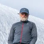
Av: andre hangaard
Preparing for a big mountain
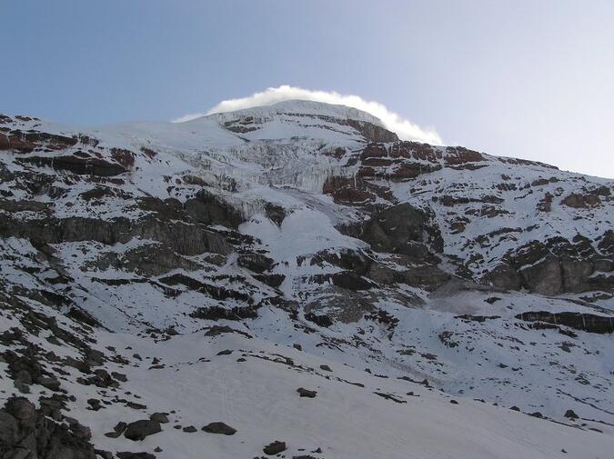
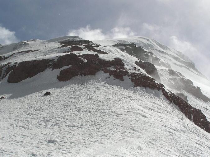
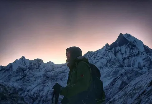
It took a while until Chimborazo revealed itself to us. It was not until a sudden 10 second- window opened up in the thick fog, while approaching El Castillo at around 7:00 am in the morning, when we could see the Veintimilla summit surrounded by white smoke of snow, violently blowing across the top. This reminded me of pictures I’ve seen of the famous jet streams blowing on top of Everest. The sight was tremendous and very powerful. This was a very big mountain, no doubt about that!
After our successful climb on Cotopaxi three days ago and with our bodies reasonably well acclimatized we sat in a car taking us southbound on the Panamericana highway towards the city of Riobamba, 188 km south of Quito. Taking all our equipment on a local bus would have been a hassle. In the centre of Riobamba our driver finally found the signpost which pointed out the direction to Guaranda, which is the small town you drive towards when heading for the Reserva de Producción Faunistíca Chimborazo, the Chimborazo National Park.
The landscape changed rapidly and was completely different from what we have seen around Cotopaxi. We drove through some small villages where the farmers were harvesting on steep slopes. To the right, covered in clouds, we sensed the presence of a huge mountain which was dominating the entire area, Chimborazo. Occasionally some clouds lifted so we could see parts of its ridges. It was early afternoon when we passed through the entrance gate to the park and paid our USD 5 fee.
The drive up to the Refugio Carell up at 4.800 m was short and the road in surprisingly good condition. Not seldom already this part can be snow covered and challenge your 4 wheel drive vehicle.
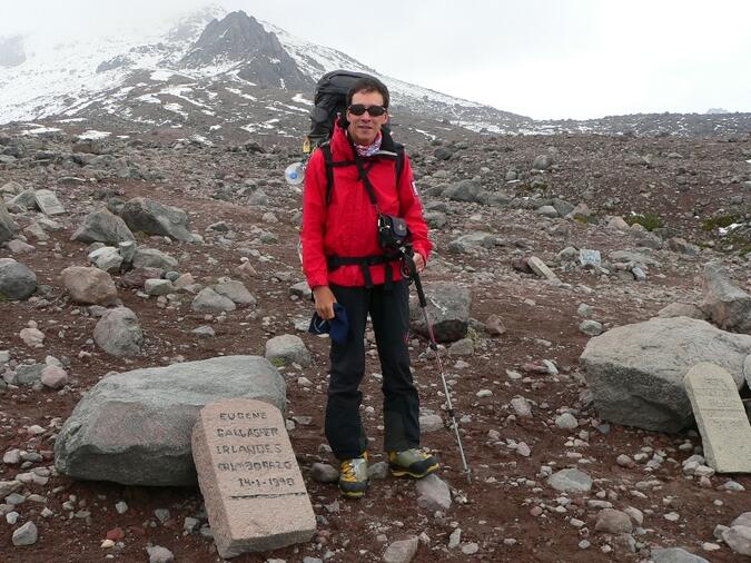
From the Carell hut it is a 45 minutes hike up to Refugio Whymper, located at 5.000 m, named after the great Englishman Edward Whymper who climbed Chimborazo in 1880. On the way towards the second hut we passed the Chimborazo graveyard with all its scattered tombstones which made us once more aware of the fact that this was a serious undertaking and not just a walk in the park.
The Refugio Whymper was much smaller than the Cotopaxihut. Obviously this hut does not get as many visitors as Cotopaxi. We installed our selves in one of the rather small rooms upstairs and sorted out our gear before we went out for an hour, scouting tomorrow’s route and fixing some strategically important GPS-points while it was still daylight. A few other climbers arrived during the evening and everyone went to sleep very early. It was cold around the hut and the entire mountain was covered in fog. Zero visibility. It started to snow.
El Corridor
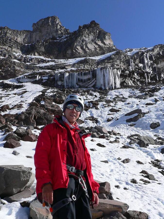
Our idea of a successful climb included a high camp and overnight up on the ridge underneath a huge rock called El Castillo. Most people climb straight from the refuge to the summit which involves 1.300 altitude meters. This is quite a lot considering the high altitude.
Apart from that it is a fantastic experience to set up a camp on a glacier on 5.500 m surrounded by nothing but mountains.
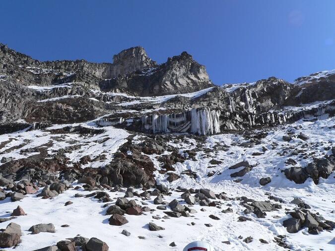
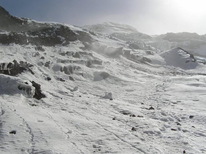
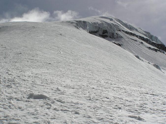
A normal ascent calls for a departure between 11:00-00:00 am but since we only were heading for the ridge up at El Castillo we could leave as late as by dawn. We were however very aware of the fact that the route up to El Castillo, called “El Corridor”, was one of the most critical and dangerous passages on the entire climb, very exposed for rock- and ice fall and a place you do not want to hang around after 12:00 pm at noon. Infact you are recommended to avoid this place already after 10:00 am. As soon as it gets warm huge deadly boulders are balancing on the fragile surface on the edge of the melting glacier above your head, just waiting to break through the thin ice layer which is holding it up and thunder downwards in rage through the steep slopes of El Corridor.
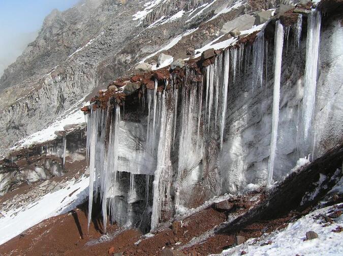
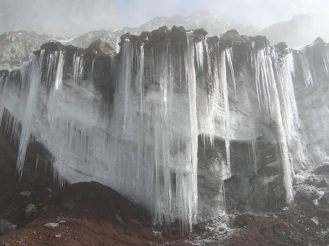
To our advantage almost the entire part of the route was covered by snow after the recent heavy snowfalls in the area. This made the rock fall hazard less. On the other hand, too much snow could of course trigger avalanches. Wearing your helmet is mandatory.
On the upper part of the corridor you climb on glaciated ground and therefore we roped up while carrying our heavy loads. The route up the corridor was surprisingly easy to find but of course it helped that daylight was on its way and that we did not have to fumble around in the dark. Only a short section of a steep gully required some front-pointing and axe-support.
The views were breathtaking and powerful. The mountain kept shutting down and opening up through the clouds in front of us. One minute we saw the outcrop of the Castillo-rock crystal clear above us, surrounded by blue skies and after 30 seconds we almost didn’t see more than a rope length away.
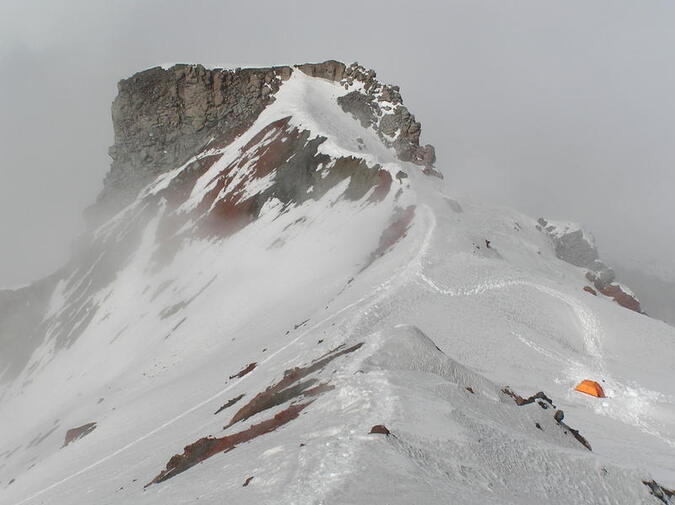
High camp on Castillo
After around three hours we stood on top of the ridge in the middle of a thick whiteout. We could not tell exactly where we were but at least we knew the direction of the Castillo rock. After waiting out the fog for a half hour we decided to explore the area around us in order to find a suitable camp site. 50 meters below the ridge we found a flat spot in the snow where we put up our tent and installed ourselves. While we took care of ordinary camp duties like melting snow and preparing pasta the clouds sunk deeper and we both realized that we should give up our hopes of seeing the great Castillo rock during what was left of the day.
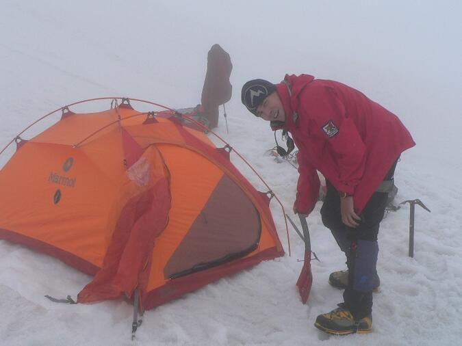
The warden down at the Whymper hut however, left us with a big smile on his face, claiming that the conditions on Chimborazo were excellent, so with his encouragement in our minds we sipped our hot tea and went to sleep in our warm sleeping bags right after 6:00 pm.
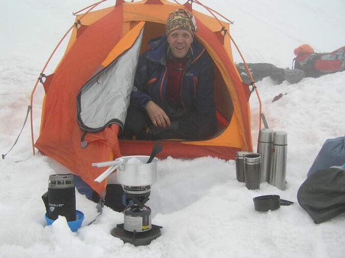
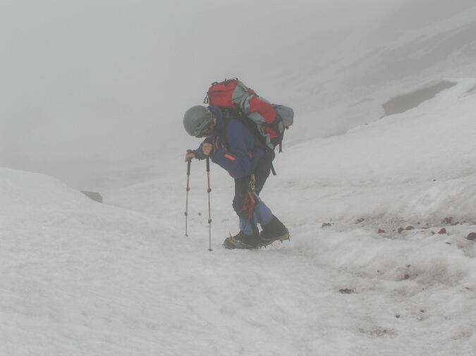
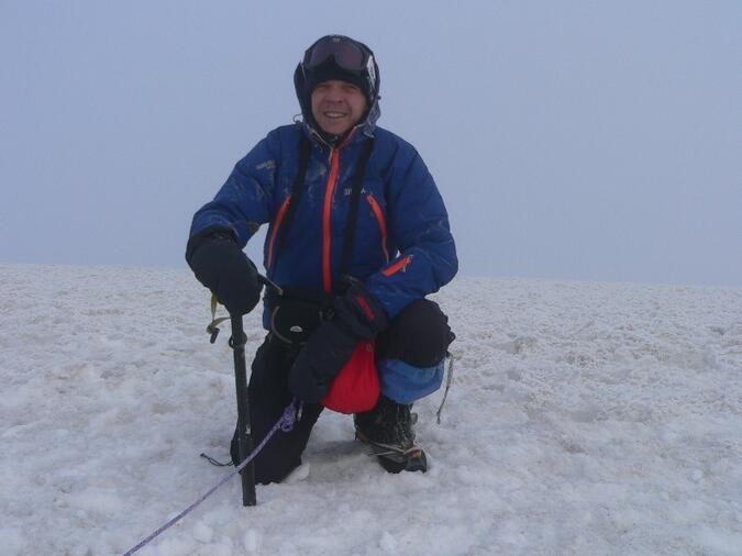
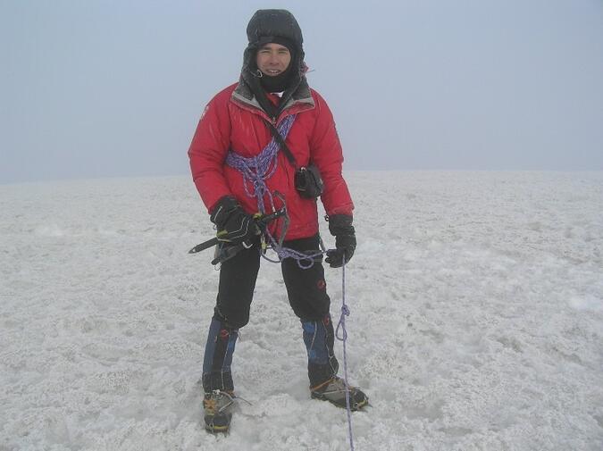
Getting up at 11:00 pm in a tent up at 5.500 m in complete darkness is a beautiful thing, especially if you know that you have an exciting summit attack on a great mountain before you. Two men getting ready in a small and packed tent is somewhat less beautiful but everything works if you really focus and at 00:45 am, after a small breakfast and some hot tea, we were roping up, putting our helmets on and made our way through the ridge, which in the beginning was narrow and had some sections with easy rock. To our great satisfaction the weather seemed to be as excellent as the warden had said. The sky above us was full of stars and the wind was almost non-existing.
We immediately saw some lights far below from ascending parties who were making their way up the El Corridor. They must have gotten slightly surprised when suddenly two head lamps turned up a couple of hundred meters above them up on the ridge.
Climbing up the flank
And so we went on. Up through the rather monotonous north-east ridge with around 40° steepness.
Up at 5.800 m the ridge became wider but the steepness more or less continued rather homogenous.
To make the ascent less strenuous we zigzagged to preserve energy and made a lot of short breaks to drink something hot. We passed the 6.000 m-line and met some of the other, faster climbing parties.
Totally I think we saw around four or five groups of people on the mountain. The people we met were as usual American or Swiss.
We moved slowly now and each step felt exhausting. We noticed however a vague change in the light and slowly the sun was about to rise. Inspired by the emerging light and due to the fact that we each minute saw more and more of the mountain we were about to climb, reinforced our strength. The snow was excellent and our crampon got good purchase.
Once more I need to point out how lucky we were with the great snow and ice conditions on Chimborazo.
I have red many reports from the Castillo route where the steep flanks were covered with blue ice and people had to belay several pitches with ice screws. During those conditions a silly mistake would have resulted in a bad and probably fatal fall down the ridge.
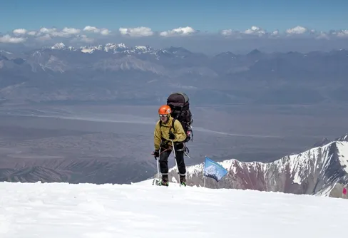
The summit plateau was obviously reached and my Suunto wristwatch showed 6.100 m.
Not very far away we saw three people standing together with their backpacks in the snow.
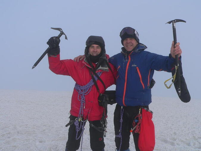
When we got closer we even saw a small yellow wand. We stood on the Veintimilla summit
and we had climbed Chimborazo. Veintimilla is recognized as the official summit.
Summiting Cumbre Whymper
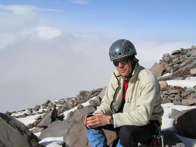
After a short break we took off our backpacks and placed them securely on the ground. We took out our cameras and started walking towards the main summit, Cumbre Whymper at 6.267 m, which was around 40 minutes further. Up on the summit plateau the terrain was flat and only a few meters in altitude difference. The ground between Veintimilla and Cumbre Whymper can sometimes hide some bad crevasses so we moved with precaution over the snow fields. One last slope to climb and there we were, on the roof of Ecuador at 07:20 am in the morning.
Here the wind was increasing and the temperature was around -7° celsius. When adding the wind-chill factor it was not a place where you walked around without gloves. It got terribly cold just after a minute or two.
To the north we saw the cone-shaped summit of Cotopaxi where we’d been just six days ago. We started our descent and moved downwards the same way as we came up. We both knew that in a coupe of hours the sun would be hitting down hard on El Corridor, soften the snow and slowly melting the ice around the boulders.
We were both quite exhausted and were forced to take some breaks while down climbing. Soon we saw a little orange dot far below at El Castillo which was our Marmot tent.
The snow condition on the slope was already a lot softer and our descent became rather tiring. Further down we discovered a few smaller and snow covered crevasses above a serac zone which reminded us that the danger is not yet over and that we need to remain sharp and alert.
We returned to our camp at around 10:00 am, packed our tent and cleaned up. By this time the clouds had already started to build up and soon it started to snow.
We roped up and began moving down El Corridor as fast as possible, carefully scanning the top of the overhanging glaciers to detect any rock fall. During descent we stepped over numerous large boulders and smaller rocks which had been tumbling down earlier and ploughed long deep lines in the snow.
At around 02:00 pm we stepped into the Refugio Whymper. Close by the hut we met an American who’d been on a hike, scouting for a possible Chimborazo climb himself and who offered us a ride using his transport back to Riobamba. This was very fortunate for us since else it can be a bit of a problem to arrange a ride out of the park if no arrangements have been made in advance.
A local bus is passing the main park entrance a couple of times during the day on scheduled service between Guaranda to Riobamba, but after a Chimborazo climb the long walk from the Carell hut to the main road might not be too appealing, especially not with lots of heavy gear.
When our taxi rolled into Quito it rained heavy and the sky was grey. The clouds were far below the Pichincha’s. Nothing, not even storm and thunder over Quito, could however spoil our good mood. Our greatest concern now, after cleaning our gear, was how to get the best table at Los Troncos, the number one steak house in town. We had spent twelve fantastic days in Ecuador and two serious projects, Cotopaxi and Chimborazo, could finally be ticked off from our to-do list.
All photos by Johan Dahlström and André Hangaard
Läs mer

Forumdiskussioner
- Expeditioner Nybörjare som ska vandra Vålådalsfyrkanten tidigt i juni? Vad ska vi tänka på?
- Expeditioner Vada längs Kungsleden?
- Klättring allmänt Stetind - Vestveggen/vesteggen
- Expeditioner Första Fjällvandingen i Nordnorge
- Klättring allmänt Hur lång livsläng har en wirekil?
- Expeditioner Långvandring i USA (CYTC) och första trailangeln i Sverige
- Expeditioner Första övervintringen i Antarktis
- Klättring allmänt Klättringspartner


Trevlig läsning. När på året var det här? Jag var själv där i juli 2006 och då fick vi lov att ta en lång omväg för att undvika El Corridor överhuvudtaget. Gillar fotot på där ni slog läger - där skulle jag också velat ha campat :)
Vi var där 8-10 Dec 2010. Vi hade kanonväder. Omväg runt El Corridor? Gick ni till höger om hyttan då alltså, sk. gamla "Whymper route"?. Ett camp på vägen underlättade turen :-)
Fantastiskt inspirerande! Fina bilder, man blir ruskigt sugen! Skulle gärna se bilderna i högre upplösning.
Tack! Jag kommer snart att lägga bilderna i originalupplösning på summitpost.org. Sök på "Chimborazo".
Grattis till bestigningen. Bra artikel!
Tackar tackar!