"The Southern Route" - Kashi/Kashgar
- Lhatze.
My logbook become very wet at several occasions and I can't read all of it. I hope you can find
at least some info that can be useful, but don't trust this one too much...
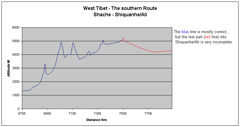
If you compare the graph from 1997 with the top one, you can see the altitude
differences are quite big in some places. Barometric altimeters are ok, but not
more. I also had lots of tecnical problems with both the altimeter and the speedometer,
so the graph is far from complete or accurate. It is a bit more detailed in
parts, than the one from 1997 and that is the only reason I put it online at
all.
 |
The incomplete graph of the first part. Shache
- Shiquanhe/Ali. |
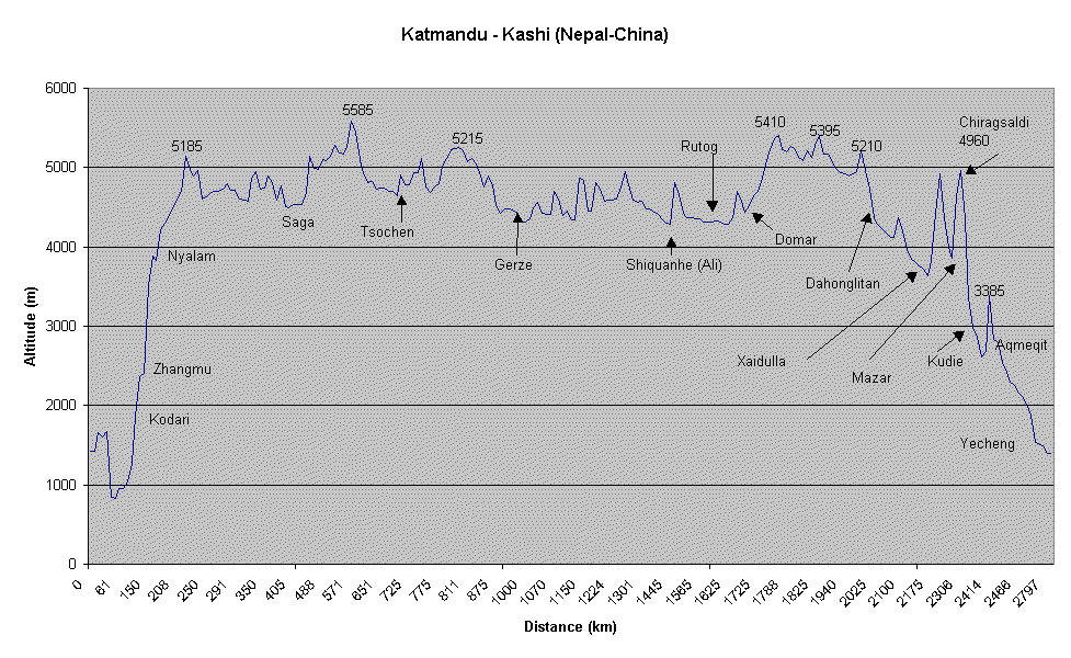
 |
The much better graph from 1997, but it is from
the opposite direction and after Shiquanhe/Ali it shows The Northern
Route. |
Table with distances and altitude and some comments.
Location
|
Distance
|
Altitude
|
|
|
|
| Shache |
0 |
1310 |
| Yecheng |
62 |
1380 |
| A Ba Km 0 |
69 |
1420 |
| Km 19 |
88 |
1590 |
| Km 50 |
138 |
1880 |
| Akmeqit |
169 |
2660 |
| Akmeqit Pass |
181 |
3310 |
| LP, RCC |
196 |
2550 |
| Kudie |
250 |
2945 |
| Km 199 |
290 |
4250 |
| RCC |
298 |
4465 |
| Chiragsaldi Pass |
310 |
4910 |
| Mazar |
334 |
3820 |
| RCC |
347 |
3875 |
| Stream |
361 |
4005 |
| Abond. RCC |
365 |
3990 |
| RCC, ruins |
384 |
4030 |
| X |
387 |
4055 |
| Climb start |
395 |
4460 |
| Shaidouli Pass |
404 |
4860 |
| RCC |
421 |
4410 |
| LP, RCC |
452 |
3660 |
| Xaidulla/Shaiduli |
462 |
3680 |
| X |
496 |
3830 |
| T.O., bridge |
505 |
3860 |
| Pass |
527 |
4250 |
| X |
538 |
3990 |
| LP |
540 |
3960 |
| X |
552 |
4075 |
| Dahonglitan |
591 |
4220 |
| X |
604 |
4390 |
| X |
612 |
4490 |
| RCC |
616 |
4615 |
| Ridge |
620 |
4780 |
| Tent (summer=food) |
627 |
4785 |
| X |
632 |
4810 |
| X |
637 |
4890 |
| Dahonglitan Pass |
641 |
5090 |
| Rest, hotel tent |
649 |
4815 |
| X |
657 |
4775 |
| LP bridge salty
water |
665 |
4760 |
| X |
755 |
4915 |
| X |
781 |
5030 |
| HP |
784 |
5075 |
| Tielong (shop+rest) |
787 |
5020 |
From here on the altimeter
didn't work very well. |
| X |
802 |
5215 |
There are more passes and
ups and downs on the way. |
| Pass |
803 |
5245 |
See the other graph. |
| X |
810 |
5015 |
| Rest |
1017 |
4250 |
| Shiquanhe/Ali |
1187 |
4285 |
|
After Shiquanhe/Ali I went the "wrong way". Instead of following
the main road I went on a shortcut , over a 5000m pass and ended up on the
northern side of the Gar river. This little screw up was to blame on leaving
Shiquanhe late at night in a rainstorm, and that in turn was to avoid the PSB.
I can't recommend what I did to anyone - I was too stubborn to give up and
followed the Gar 180km upstream, 'til I hit the source of the river. May have
been able to get over the glaciers, but decided against it. No food and there
was no way to tell if there was any way to get down to the main road again.
Under normal conditions, you'll be able to cross the Gar easily in many
different places, but not during the monsoon season.
The info below is along the main/normal route. If you for some reason wanna
go up to the Gar river source, contact me for info.
All km info are approximates.
- 40km from Shiquanhe. Bridge, small shop and restaurant.
- Bad road. Loads of river crossings, no big ones.
- 96km further on Namru. Shop, restaurant. Watch out for ripoffs!
- Pass.
- Food stop.
- Jerko pass. Many summits, muddy when I was there. Lots of pretty nasty
dogs. Nomads may sell you food. Last summit 4840m.
- Bad road condition on downhill and in the valley after the pass.
- Moincer. Shops, hotels (badly overpriced, some with real asshole owners)
and restaurants. 4500m.
- Flat pass at 4840m.
- Darchen 4600m+. Alert roaming PSB. Shops, hotels, campground compound.
- Barga. 4600m. Checkpoint in the middle of town. Pass on left side, in the
outskirts, to avoid it.
- Horqu, about 25 km away from Barga. There are a military checkpoint in
town, but I had no problems with those guys. Good shops and hotels. Shop
here, next place is pretty far away.
- Minipass a couple of km out of Horqu.
- Approx. 50km from Horqu small rivers full with fish. You can catch them by
hand or stone them. Nice grass plains at 4700-4800m.
- Sandy.
- Slow climb to 4925m, down to 4850m and up again to 4935m.
Ok roads.
- 15km of slow climb to Mayum Pass at 5135m. Last part steeper.
- Long gradual downhill.
- Big new bridge approx. 30km after the pass.
- Corrugations and sand, no water.
- Road conditions vary: sand/corr./ok on flat road for approx. 80km.
- Paryang. Hotels, restaurants, shops. Bargain hard for the hotel price.
- 17km of ok roads. Climb to 4730m ok/sandy. New short climb to 4715m.
Lowest point between these two small passes are approx. 4600m.
- "Old" Zhongba". Checkpoint=no problem. Shop, rest, hotel.
Watch out here, the bitch who run the place, quoted us different prices
before checking in to the hotel and eating and three resp. four times higher
after.
- "New Zhongba". Loads of great shops and restaurants. PSB
approached us and...invited us for dinner!
- Very corrugated roads before Old Zhongba and much better roads after.
- RCC,s and road markers are back after Zhongba.
- 59km after Old Zhongba there's a restaurant and there's also a small pass
at 4865m.
- Speedometer started to work again!
- 1820 4600 village, shop.
- 1838 4820 pass, steeper the last 3-4km
- Steep bad downhill to Saga.
- Saga. Many great shops and restaurants. Hotels.
- 1890 5080 4,5-6% steady switchback climb. The first real pass for some time!
- 1906 turn off to the Northern Route.
- 1912 4935 Raka. Rest, hotels, shops. Avoid the hotel on the left hand side
after the checkpoint (no problem), the guy has a very bad temper when drunk.
- 1951 5040 4-6%
- 1980 rest, shop. Hopefully the bridge is ok, by now...
- 1988 4880 steep climb in ravine. Lowest point in valley after pass 4580m.
- 2024 Sangsang. Everything.
- 2035 4795 Pass steep and beautiful.
- 2050 4720 Steep.
- 2075 Village, rest, shop, hotel, great food in "Public bath public
room butter tea Hotel".
- 2085 4385 Gaya/Kaya. Rest+shops.
- 2091 4575 pass.
- A mad downhill, full of river crossings, road contruction etc. Hopefully
fine by now.
- A wide valley opens up and you arrives at the the junction some 10 odd km
from Lhatze. Checkpoint, rest, hotels. Everything available in Lhatze.
Route info for The Friendship Highway.
Photos from this
journey.
Back to main statistics
page.
Back to main!