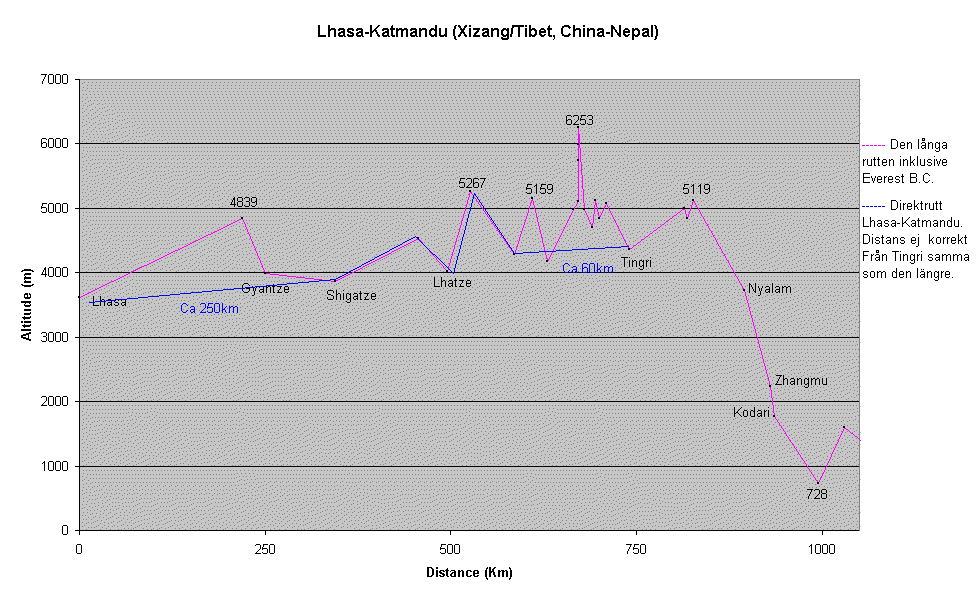
 Graph.
The Route: Good road condition, asphalt to Shigatze and gravel to Barabhise in Nepal. Only two major (four if you choose to detour via Gyantze) passes. Easy to find food and water. Quite a lot of traffic, Tibetan standards. With the exception of the views of "The High Himalayas", this route doesn't even come close to the other routes. The transition from high plateau to subtropical lowlands is fantastic, regardless of direction. The Tibetans along the route is pretty pushy (begging) and sometimes aggressive. Short and easy route without any bigger surprises.
Graph.
| Comment | Dist. (km) | Alti. (m) | |
|
Lhasa |
0 |
3620 |
|
|
Yung pass |
220 |
4839 |
|
|
Gyantze |
250 |
3992 |
|
|
Shigatze |
345 |
3860 |
|
|
Tsou pass |
457 |
4534 |
|
|
Lhatze |
495 |
4016 |
|
|
Gyotso pass |
527 |
5267 |
|
|
Shegar |
585 |
4280 |
|
|
Pang pass |
610 |
5159 |
|
|
Phadruchi |
630 |
4180 |
|
|
Rongbuk |
665 |
4980 |
|
|
Everest base camp |
672 |
5105 |
|
|
Camp 1 |
Uncycleable! |
5740 |
|
|
Camp 2 |
Uncycleable! |
5986 |
|
|
Advanced base camp |
Uncycleable! |
6253 |
|
|
Rongbuk |
680 |
4980 |
|
|
LP |
690 |
4700 |
|
|
Zommug pass (trek) |
Push/carry bike! |
695 |
5116 |
|
LP |
700 |
4850 |
|
|
Lamna pass |
710 |
5071 |
|
|
Tingri |
740 |
4359 |
|
|
Lalung pass |
815 |
5000 |
|
|
LP RCC |
819 |
4844 |
|
|
Yarlung Shan pass |
826 |
5119 |
|
|
Nyalam |
895 |
3728 |
|
|
Zhangmu |
930 |
2228 |
|
|
Kodari (CP-bridge) |
935 |
1776 |
|
|
Dolalghat LP |
995 |
728 |
|
|
Dhulikel pass |
1030 |
1591 |
|
|
Katmandu |
1055 |
1359 |
The Route: Good asphalt to the turn off to Gonggar airport. Three alternative routes up the Kampa Pass: 1. Easy not so steep, good condition road. 2. Bad, rocky, very steep and in parts washed away road. 3. In parts steep, ok condition with very nice views over the whole valley. The info above is about route 3. Beautiful, easy cycling to Nagartze. Gradual and easy climbing towards Karo Pass, last 3 km steeper. The pass is infamous for bad weather. Lots of rock throwing kids between Gyantze and Shigatze.
 Graph.
| Location | Distance (km) | Alt. (m) | |||
| Lhasa | 0 | 3800 | |||
| X | 25 | 3790 | |||
| X | 50 | 3775 | |||
| Quxu | 65 | 3800 | |||
| T.O. Gongar airport+S. route | 71 | 3820 | |||
| T.O. In village | 86 | 3800 | |||
| 10 km up pass | 96 | 4260 | |||
| 15 km up pass | 101 | 4490 | |||
| 20 km up pass | 106 | 4595 | |||
| 25 km up pass | 111 | 4700 | |||
| Connect. to main road | 115 | 4895 | |||
| Kampa Pass | 116 | 4945 | |||
| Lake level | 122 | 4625 | |||
| Nagartze | 153 | 4600 | |||
| T.O. to southern small roads | 160 | 4700 | |||
| X | 170 | 4835 | |||
| Karo Pass | 181 | 5175 | |||
| X | 191 | 4730 | |||
| X | 221 | 4370 | |||
| Small Pass | 223 | 4440 | |||
| Village | 230 | 4315 | |||
| Gyantze | 267 | 4160 | |||
| Shigatze | 353 | 4035 | |||
Photos from these outes: 1996 and 2000