 Graph.
The Route: Hard but very beautiful! One of my absolute favourites. What really makes it hard is the numerous checkpoints-lots of night time checkpoint-dodging. The topography also takes it's toll, not many flat meters, lots of long hard climbs and quite a lot of dog attacks. The road condition is most of time ok, dirt roads almost all the way from Zhongdian to 25km from Lhasa. Food is never a problem, the nature is fantastic and very diverse. I could give you a list of where the checkpoints are, but I've heard it changes pretty much from year to year. Be careful in every decent sized town and NEVER sleep in any hotel-you WILL get caught by the PSB!
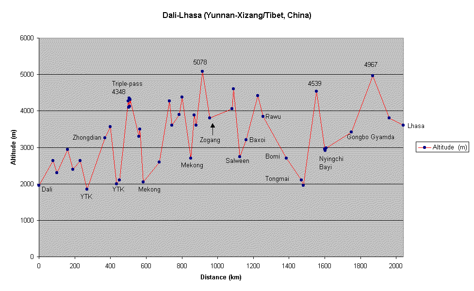
Graph.
| Location | Distance | Altitude | Position | Position | Chinese Passmarkers | Checkpoints |
| (km) | (m) | Latitude | Longitude | Alt.(m) | ||
| Dali | 0 | 1950 | ||||
| Pass | 80 | 2636 | ||||
| LP(Lowest Point) | 100 | 2300 | ||||
| Pass | 160 | 2941 | ||||
| Lijiang | 190 | 2400 | N26°52.886' | E100°13,646' | ||
| Pass | 230 | 2632 | ||||
| YangTzeKiang (LP) | 270 | 1850 | ||||
| Zhongdian | 370 | 3256 | N27°49.660' | E99°41,931' | Be careful | |
| Pass | 400 | 3560 | ||||
| YangTzeKiang | 435 | 2000 | ||||
| Benzilan | 450 | 2100 | Cool | |||
| Pass (three summits) -1 | 500 | 4276 | ||||
| LP | 502 | 4100 | ||||
| -2 | 506 | 4348 | N28°21,142' | E99°02,737' | ||
| LP | 508 | 4120 | ||||
| -3 | 511 | 4316 | ||||
| Deqen | 560 | 3300 | Cool, but be alert | |||
| Pass | 565 | 3500 | ||||
| Mekong (LP) | 585 | 2050 | ||||
| Yanjing | 675 | 2600 | CP, Barrier | |||
| Pass | 730 | 4268 | N29°15,824' | E98°40,774' | 4470 | |
| LP | 745 | 3600 | ||||
| Markam | 785 | 3900 | CP on the Sichuan Route, informer town. | |||
| Pass (two summits) | 800 | 4378 | N29°41,798' | E98°31,504' | 4139 | |
| Chuka/Mekong (LP) | 850 | 2700 | Cool | |||
| Pass | 870 | 3890 | N29°33,164' | E98°18,962' | 3908 | |
| LP | 880 | 3600 | ||||
| Pass | 915 | 5078 | N29°42,631' | E98°00,223' | 5008 | |
| Zogang | 955 | 3800 | Be careful | |||
| Bamda | 1080 | 4060 | Cool | |||
| Pass | 1090 | 4609 | N30°09,404' | E97°18,605 | 4618 | |
| SalweenBridge (LP) | 1125 | 2740 | CP, military, cool | |||
| Baxoi | 1160 | 3200 | Sometimes a barrier | |||
| Pass | 1225 | 4417 | N29°40,172' | E29°43,102' | 4350 | |
| Rawu | 1255 | 3840 | Be alert | |||
| Bomi | 1385 | 2700 | Dangerous | |||
| Tongmai | 1470 | 2100 | Cool | |||
| LP | 1480 | 1960 | ||||
| Pass | 1555 | 4539 | N29°36,656' | E94°39,429' | ||
| Nyingchi | 1600 | 2960 | Dangerous | |||
| LP | 1604 | 2908 | ||||
| Bayi | 1609 | 2976 | CP, no barrier, very dangerous | |||
| Gongbo Gyamda | 1750 | 3420 | Be careful | |||
| Pass | 1870 | 4967 | N29°43,633' | E92°20,632' | 5070 | |
| Maizhokunngar | 1960 | 3800 | Cool | |||
| Lhasa | 2040 | 3606 | N29°39,298' | E91°07,868' | You're safe |
The information about the checkpoints has to be taken with a pinch of salt. It changes from year to year and this was how it was when I went through in 1996. I have been talking to other cyclists who have been in the area later on, and it seems like it's basically the same. Yanjing is supposed to be open nowadays. As I see it, Markam, Bomi and especially Bayi is the main danger spots.