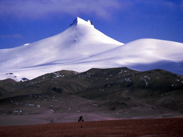
Nadine cycling in front of Kangzhangri/Konung Oskar's Fjäll, 6305m.
A very brief report with some basic information. More will come later.
Chronology of events.
In 1997 I took my first ride on the Chang Tang. I was there in the winter time and only cycled a bit in the outskirts of it. I really got intrigued by the vastness, desolation and grandeur of nature. An obsession was born.
Year 2000 it was time for a crossing of the whole plateau from the north to the south. Due to incorrect route descriptions from a wannabe mountain guide/expedition leader, we ended up being stuck in the northern parts of the Kunlun mountain range for two weeks. No way to even get up unto the plateau.
In the year of 2002, we tried again. First we wanted to make some “warm-up” cycling. We planned to go along the standard route from Kashi/Kashgar on the Xinjiang highway onto the plateau and over the Kerriya Shankou/Pass. We did, but underestimated the difficulties and we ended up in a very dangerous situation in areas where for example great explorer Sven Hedin had had to turn around. Bowen, another explorer lost many men there and we were actually happy to get out of it alive. After that episode, we were in no condition to continue with our plan to cross the whole of the Chang Tang, but as a reward we had made the first un-supported crossing of the Kerriya-route.
2003. Still obsessed with the idea, we made another try. Started from Gansu province and continued through the high altitude deserts of Qinghai province. Had some minor trouble with “forbidden areas” due to oil prospecting and lost contact with an expedition member because of Chinese protective interests.
In mid September, Nadine and I were finally on a small sandy path on the northern side of the Altun Shan mountains and were about to start our traverse of the mighty Chang Tang.
It all begun fine and the progress in the dry and sandy areas went on at a good speed. We had to watch out for oil prospectors and rangers but avoided detection. The wildlife and sightings of birds of pray, Kiang (Tibetan Wild Donkey), foxes, Marmots and Pika (a small rodent) increased by the day.
We made a bad choice of routes at Ayakkum Lake (one of the world’s largest salt lakes). Had no change to make it over to the southern side of the huge river. Had to turn back and lost six days. Made it over the first high Aqqikol Pass at 5100m. Splendid views of “the world’s most desolate and inaccessible mountain” – Ulugh Muztagh 6900m.
More encounters with animals, bear, wolf, wild yaks and Chiru (Tibetan antelope).
Larger difficulties to find the route. Sand, mountain ranges and mud slowed us down more and more. After crossing the two high passes of the Kunlun, the wind increased to an average of 15m/s for the rest of the journey and night temperatures fell to – 30 C. One of our side goals of the expedition was to climb Kangzhangri/Konung Oscars Fjäll, one of earth’s highest (6305m) unclimbed mountains. Deep snow, avalanche risk, high winds and the safety aspects made us pass. After all, we were 420 km and 22 days from the closest outpost of civilization and a solo attempt (Janne) would’ve bordered to suicide.
Nadine cycling in front of Kangzhangri/Konung Oskar's Fjäll,
6305m.
Our calorie intake was low, as expected. We had realized that we couldn’t bring enough supplies to keep a necessary level of energy and after 30 days in the wilderness we started to feel it. All our waking time was focused on food and we started to look for any type of stuff we could eat. We tried to do as the bears in the area, i.e. dig the Pikas out of their holes in the ground. We chased eagles and other predators away from their prey and at several occasions we thought about carving some meat of carcasses of larger animals we found along the route.
River crossings were a big hassle. One single big river could’ve stopped our project and also probably killed us. Had to time the crossings well and make our passage early in the mornings. Nervously and carefully we crossed the over frozen rivers and hoped that the ice wouldn’t break. Most of the time the crossings went fine, but we fell through at a couple of occasions, which resulted in frost bite.
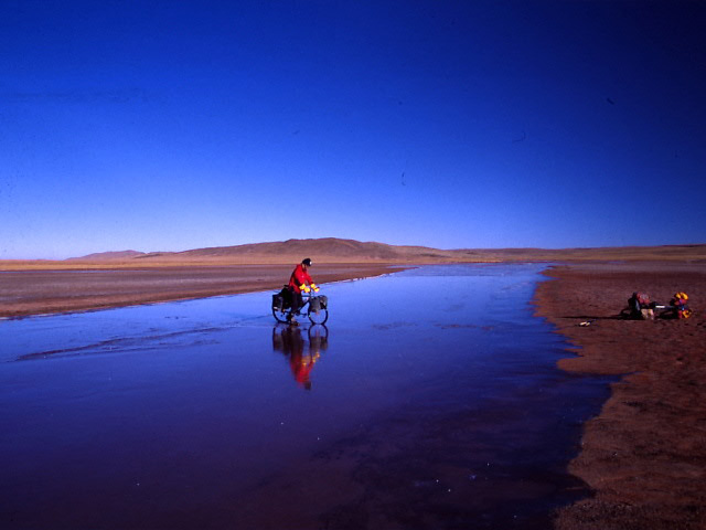
Carefully over a river. The top layer of ice broke, but the
second thicker layer took me over to the other side.
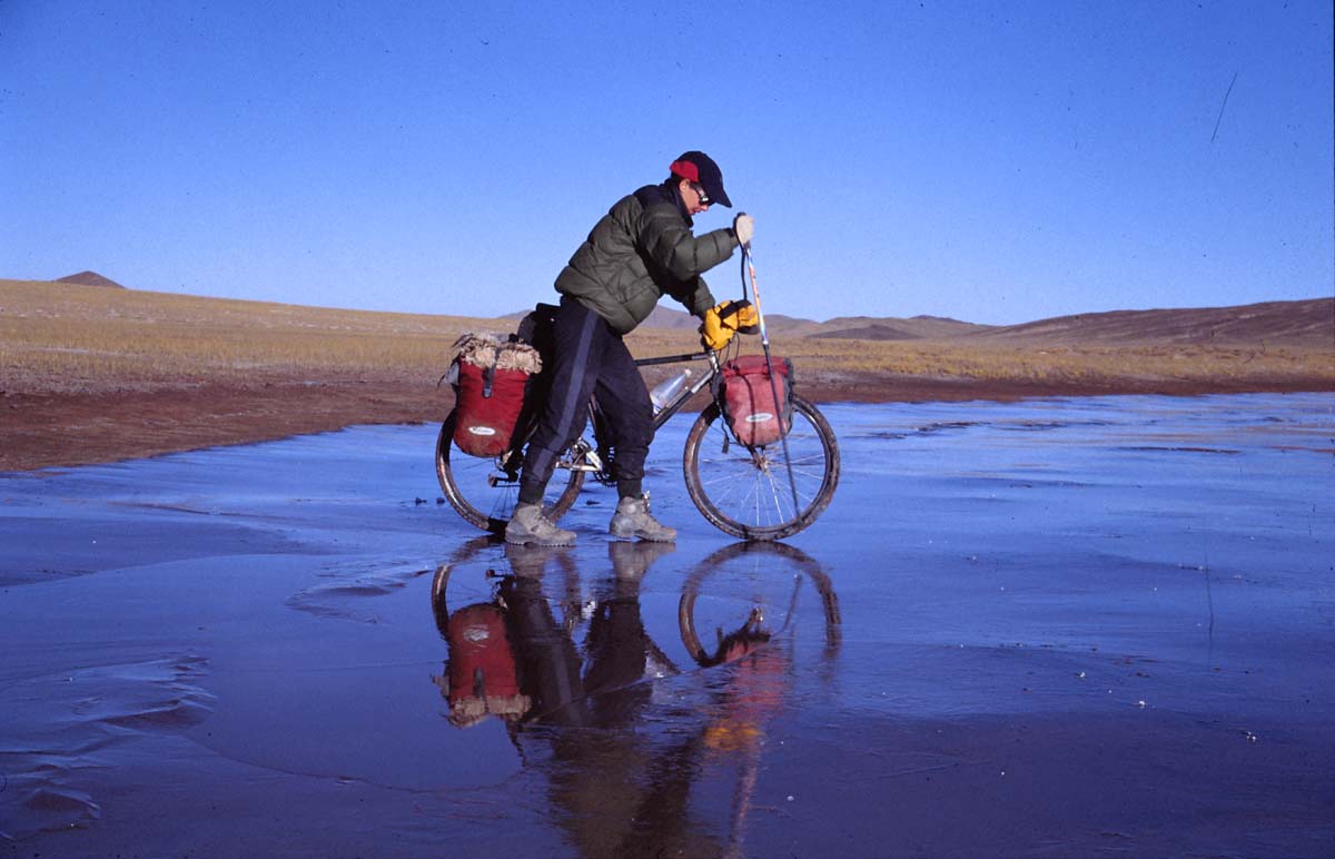
Nadine negotiating the ice on a frozen river. Approx. -20C.
The last week was nothing but a struggle for sheer survival. The daily distances had gone down to about 10 km/day and starved we stumbled towards or goal in the south. The wind and terrain did their best to stop us, but finally we saw the mountain range in the distance where we knew there should be a road.
After 46 days and 1050 km in road less country we reached the southern brink of the Chang Tang. We had lost a lot of weight (13 kg each), were mentally wasted from the uncertainty of making it or not and the frost bite had gone worse.
The ultimate anticlimax was a fact when we got arrested as soon as we arrived in civilization. As the few explorers that had made it over the Chang Tang, we got in trouble with the authorities and therefore didn’t succeed to do what a no one had done before – to link the Silk Route with Lhasa.
Anyway, we made it through one of harshest parts of the world and we were the first ever to do it with bicycles. Nadine was the first woman and there has only been one successful attempt before at all.
The PSB transported us to Nagqu for further
interrogations. It looked bad for us for some time, but after a couple of hours
of negotiations, explanations, double-checking of documents and in the end small fines we were released, but only after changing the
story from the truth to a lie – the police found it unrealistic and impossible
that we had made it over the Chang Tang.
“NO, that is over a 1000km of wilderness, no food,
no roads, lots of mountain ranges over 5000m and no one has done it before –
tell us the truth!”
Long rest in Lhasa. It took me three weeks to get back to some sort of normal life, but when leaving Lhasa for East Tibet, I still felt weak. We had planned to do some touring along obcure small roads, but decided to take the easy way, which still is quite demanding.
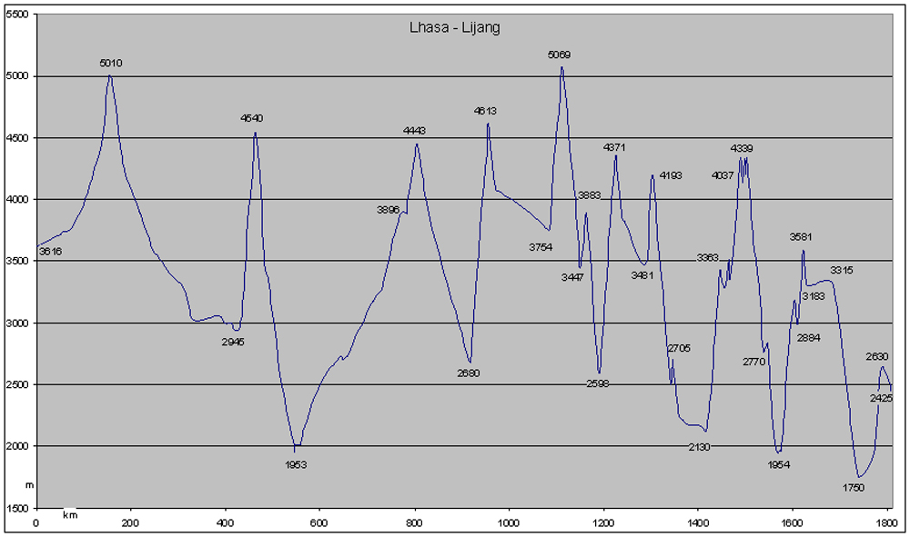
Graph of the normal route through the east.
Usually this route is full of checkpoints and police trouble, but we got through without much hassle. Don't know if this was because of an easing on the policy or if it was because we did it in mid-winter. Anyway, the route is fantastic! When arriving in Yunnan province, we decided to let Burma wait for a later occassion. We had had a nice 6-month journey full of adventures and it felt like we couldn't take in more impressions. Back home via Bangkok.
More photos and the full story later.