Tian Shan
The Route:
A long climb to start with. Actually one of the longest in China and therefore
also in the world. Good asphalt and little traffic all the way. Some bumpy
gravel roads, but mostly good road conditions. Lots of aggressive dogs in parts,
arm yourself with rocks and don't expect any help from the nomadic population,
even if they see you're under attack (strange...). There are never a day without
possibillities to buy some food. Water is usually plenty. Beautiful landscape
all along the route.
Graph:
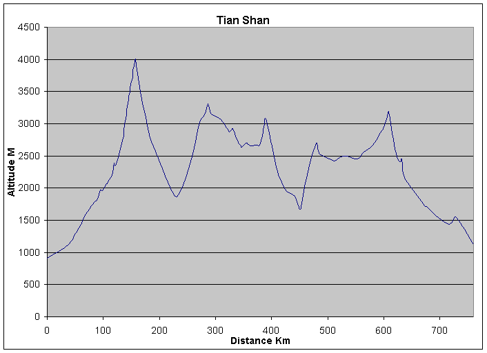
| Distance | Altitude | Km Markers | Comment | |||
| 0 | 910 | Wulumuchi Airport | ||||
| 38 | 1120 | Bridge | ||||
| 48 | 1260 | x | ||||
| 51 | 1295 | The Center of Asia | ||||
| 52 | 1305 | Sardaban Xian | ||||
| 58 | 1405 | x | ||||
| 61 | 1455 | 707 | Small city | |||
| 68 | 1590 | 713 | x | |||
| 75 | 1670 | 720 | x | |||
| 83 | 1770 | 728 | TO | |||
| 85 | 1790 | 730 | x | |||
| 90 | 1835 | 735 | canyon starts | |||
| 95 | 1970 | 740 | end canyon | |||
| 98 | 1965 | 743 | mil camp, multiple to's | |||
| 105 | 2060 | 750 | what a view! | |||
| 107 | 2070 | 752 | hell! Everything | |||
| 111 | 2135 | 756 | even worse? Everything + gas station | |||
| 115 | 2205 | 760 | difficult to find campspots | |||
| 119 | 2385 | 764 | x | |||
| 120 | 2350 | 765 | x | |||
| 125 | 2445 | 770 | x | |||
| 135 | 2775 | 780 | steeper | |||
| 136 | 2855 | 781 | no more asphalt | |||
| 137 | 2895 | 782 | x | |||
| 138 | 2955 | 783 | x | |||
| 139 | 3035 | 784 | x | |||
| 140 | 3100 | 785 | from here on: good camping + water | |||
| 141 | 3170 | 786 | x | |||
| 142 | 3210 | 787 | x | |||
| 143 | 3270 | 788 | x | |||
| 144 | 3325 | 789 | x | |||
| 145 | 3385 | 790 | x | |||
| 146 | 3470 | 791 | x | |||
| 147 | 3510 | 792 | x | |||
| 148 | 3535 | 793 | x | |||
| 149 | 3600 | 794 | rest. Glaciology station | |||
| 150 | 3650 | 795 | switchbacks starts for real, NO more camping! | |||
| 151 | 3685 | 796 | x | |||
| 152 | 3755 | 797 | x | |||
| 153 | 3820 | 798 | x | |||
| 154 | 3870 | 799 | x | |||
| 155 | 3915 | 800 | x | |||
| 156 | 3965 | 801 | x | |||
| 157 | 4005 | 802 | possible to camp on ridge east side of pass! | |||
| 160 | 3845 | 805 | x | |||
| 165 | 3570 | 810 | from 407 camp poss. | |||
| 170 | 3325 | 815 | 416 rcc | |||
| 175 | 3145 | 820 | x | |||
| 180 | 2920 | 825 | village, nothing | |||
| 185 | 2755 | 830 | to to right switchback climb, looks interesting! | |||
| 187 | 2700 | 832 | to to the left, good road. | |||
| 188 | 2675 | 833 | ||||
| 192 | 2605 | 837 | ||||
| 205 | 2300 | 850 | ||||
| 215 | 2090 | 860 | ||||
| 225 | 1920 | 870 | ||||
| 231 | 1860 | 864/551 | Balgontai, everything | |||
| 242 | 2050 | 540 | X | |||
| 252 | 2305 | 530 | X | |||
| 262 | 2625 | 520 | X | |||
| 272 | 3025 | 510 | X | |||
| 274 | 3075 | 508 | Only fragments of asphalt from here on | |||
| 282 | 3160 | 500 | X | |||
| 287 | 3310 | 495 | Pass, steeper last 2 km | |||
| 292 | 3160 | 490 | X | |||
| 302 | 3110 | 480 | X | |||
| 310 | 3060 | 472 | RCC | |||
| 312 | 3035 | 470 | X | |||
| 322 | 2915 | 460 | X | |||
| 325 | 2875 | 457 | LP | |||
| 330 | 2915 | 452 | Rest, shop | |||
| 331 | 2920 | 451 | HP | |||
| 342 | 2685 | 440 | X | |||
| 345 | 2660 | 437 | X | |||
| 347 | 2640 | 435 | X | |||
| 356 | 2700 | 426 | River/Bridge | |||
| 362 | 2655 | 420 | X | |||
| 372 | 2665 | 410 | X | |||
| 376 | 2660 | 406 | Vill, rest, shop, TO | |||
| 378 | 2655 | 404 | X | |||
| 382 | 2770 | 400 | X | |||
| 386 | 2955 | 396 | Bridge | |||
| 390 | 3070 | 392 | Pass | |||
| 402 | 2595 | 380 | X | |||
| 412 | 2215 | 370 | Asphalt | |||
| 418 | 2090 | 364 | Town, everything | |||
| 427 | 1945 | 355 | ||||
| 442 | 1875 | 340 | ||||
| 450 | 1670 | 332/776 | TO | |||
| 454 | 1765 | 780 | X | |||
| 459 | 2020 | 785 | X | |||
| 464 | 2205 | 790 | X | |||
| 469 | 2395 | 795 | X | |||
| 474 | 2545 | 800 | X | |||
| 479 | 2695 | 805 | Passmarker | |||
| 480,5 | 2685 | 806,5 | Passmarker | |||
| 485 | 2555 | 811 | Flattens out | |||
| 492 | 2495 | 818 | TO | |||
| 507 | 2445 | 833 | Bayanbulak, everything | |||
| 513 | 2425 | 839 | LP | |||
| 524 | 2485 | 850 | X | |||
| 534 | 2495 | 860 | X | |||
| 554 | 2455 | 880 | Bridge TO | |||
| 564 | 2560 | 890 | X | |||
| 571 | 2595 | 897 | Rest, shop, leaving the plains | |||
| 574 | 2615 | 900 | X | |||
| 584 | 2710 | 910 | X | |||
| 594 | 2860 | 920 | X | |||
| 599 | 2920 | 925 | X | |||
| 604 | 3040 | 930 | X | |||
| 607 | 3165 | 933 | Tunnel start | |||
| 609 | 3190 | 935 | Talamat tunnel/pass | |||
| 614 | 2925 | 940 | X | |||
| 620 | 2615 | 946 | End/start switchbacks | |||
| 624 | 2485 | 950 | X | |||
| 628 | 2410 | 954 | Dalong town | |||
| 632 | 2455 | 958 | Big Dragon Lake | |||
| 633 | 2380 | 959 | Little Dragon Lake | |||
| 637 | 2160 | 963 | Korgan, rest, Switchbacks | |||
| 666 | 1805 | 992 | Shops, rest | |||
| 674 | 1715 | 1000 | X | |||
| 676 | 1715 | 1002 | Yaxkhotan, rest, shops | |||
| 683 | 1660 | 1009 | Agi, gas station | |||
| 699 | 1530 | 1025 | Tian Shan "Grand Mysterious Canyon" tourist resort | |||
| 717 | 1435 | 1043 | Agi Xian | |||
| 728 | 1555 | 1054 | Gas station, rest, shop | |||
| 740 | 1400 | 1066 | TO to Aksu | |||
| 749 | 1285 | 1075 | Devil's Gorge Xaldarang | |||
| 760 | 1120 | 1086 | Oasis town of Xamalbag | |||


