 Graph.
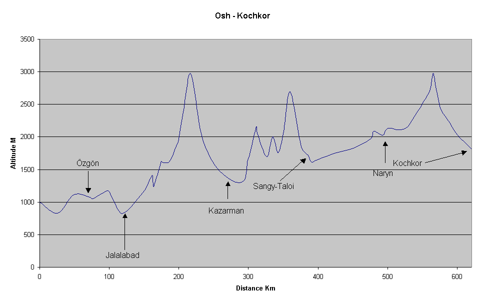
Easy to start with, but later on the road conditions get rough. Some steep climbs on rough surface. Easy to find food and water. Had some trouble with drunks and some other weird behaviour. Green and varied scenery. Recommended.
Graph.
|
Location |
Distance from Osh |
Altitude |
Distance from Cairo |
Comment. |
| Osh | 0 | 995 | 7474 | |
| Kara Suu | 26 | 830 | 7500 | |
| HP | 49 | 1115 | 7523 | |
| Özgön | 72 | 1075 | 7546 | |
| X | 76 | 1055 | 7550 | |
| HP | 97 | 1175 | 7571 | |
| X | 101 | 1125 | 7575 | |
| Jalalabad | 116 | 840 | 7590 | |
| X | 126 | 870 | 7600 | |
| X | 151 | 1180 | 7625 | |
| HP | 162 | 1410 | 7636 | |
| LP | 164 | 1240 | 7638 | |
| HP | 175 | 1630 | 7649 | |
| X | 176 | 1615 | 7650 | |
| X | 186 | 1620 | 7660 | |
| X | 196 | 1860 | 7670 | |
| Steep climb start | 199 | 1925 | 7673 | |
| X | 206 | 2380 | 7680 | |
| Pass | 216 | 2975 | 7690 | Nice guys in radio station |
| X | 227 | 2365 | 7701 | |
| Flatter | 234 | 1960 | 7708 | Weird people in this area |
| X | 252 | 1555 | 7726 | Same |
| Kazarman | 277 | 1325 | 7751 | Same |
| Climb start | 294 | 1335 | 7768 | Same |
| flattens out | 299 | 1645 | 7773 | |
| X | 301 | 1700 | 7775 | |
| Pass | 311 | 2150 | 7785 | |
| Dödömöl/Isan | 313 | 2055 | 7787 | |
| LP | 326 | 1695 | 7800 | |
| Minipass | 335 | 2000 | 7809 | |
| River, LP | 343 | 1760 | 7817 | |
| X | 351 | 2090 | 7825 | |
| Pass | 360 | 2695 | 7834 | Uncertain dist. |
| X | 376 | 1850 | 7850 | |
| Sangy-Talai | 386 | 1720 | 7860 | |
| Naryn River | 391 | 1610 | 7865 | |
| X | 401 | 1660 | 7875 | |
| X | 426 | 1760 | 7900 | |
| X | 451 | 1830 | 7925 | |
| X | 476 | 1975 | 7950 | |
| Minipass | 480 | 2090 | 7954 | |
| Central Naryn | 493 | 2030 | 7967 | |
| X | 501 | 2130 | 7975 | |
| X | 526 | 2135 | 8000 | |
| X | 552 | 2545 | 8026 | |
| Steep climb start | 561 | 2735 | 8035 | |
| Pass | 566 | 2975 | 8040 | |
| Good camp | 570 | 2730 | 8044 | |
| X | 576 | 2445 | 8050 | |
| T.O. Sary Bulak | 586 | 2270 | 8060 | Uncertain distance |
| X | 601 | 2025 | 8075 | |
| Kochkor | 621 | 1810 | 8095 |