 The route.
The route.
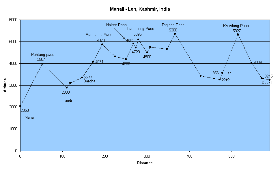 Graph.
| Location | Distance | Altitude Processed | Altitude raw | ||
| Avocet | GPS | Indians | |||
| Manali | 0 | 2050 | 2050 | 2050 | |
| Rohtang Pass | 52 | 3987 | 3976 | 3997 | 3978 |
| Tandi | 110 | 2888 | 2888 | ||
| Keylong | 118 | 3096 | 3096 | ||
| Darcha | 146 | 3344 | 3344 | 3350 | |
| ZZ Bar | 172 | 4071 | 4072 | 4070 | |
| Baralacha Pass | 194 | 4870 | 4872 | 4868 | |
| Sarchu | 225 | 4313 | 4300 | 4325 | |
| LP | 250 | 4200 | 4200 | ||
| Nakee Pass | 268 | 4903 | 4888 | 4917 | |
| LP | 273 | 4720 | 4720 | ||
| Lachulung Pass | 279 | 5095 | 5032 | 5158 | 5065 |
| Pang | 300 | 4500 | 4464 | 4535 | |
| Moore Plains Start | 307 | 4752 | 4752 | ||
| Moore Plains End Debring | 347 | 4660 | 4660 | ||
| Taglang Pass | 366 | 5360 | 5296 | 5423 | 5360 |
| Upshi | 427 | 3432 | 3432 | ||
| LP | 472 | 3252 | 3252 | ||
| Leh | 478 | 3561 | 3560 | 3562 | |
| Khardung Pass | 515 | 5327 | 5312 | 5342 | 5514 |
| Khardung | 547 | 4036 | 4036 | ||
| Khalsar | 571 | 3324 | 3324 | ||
| Deskit | 590 | 3245 | 3288 | 3201 | |
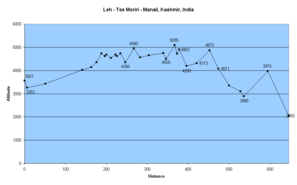 Graph.
| Location | Distance | Altitude Processed | Avocet | GPS | ||
| Leh | 0 | 3561 | 3560 | |||
| LP | 6 | 3252 | 3252 | |||
| Upshi | 51 | 3432 | 3423 | |||
| Churnathang | 141 | 4016 | 4016 | |||
| Mahe Bridge | 163 | 4136 | 4136 | |||
| Bifurcation Tso Moriri/Tso Kar | 176 | 4356 | 4356 | |||
| Namshang Pass | 188 | 4739 | 4756 | 4721 | ||
| LP | 196 | 4620 | 4620 | |||
| Hill | 200 | 4684 | 4684 | |||
| Tso Moriri - North end | 211 | 4541 | 4503 | 4578 | ||
| Hill | 222 | 4684 | 4684 | |||
| LP | 226 | 4620 | 4620 | |||
| Namshang Pass | 234 | 4739 | 4756 | |||
| Bifurcation Tso Moriri/Tso Kar | 246 | 4356 | 4356 | |||
| Polokong Pass | 267 | 4940 | 4916 | 4964 | ||
| Tso Kar | 282 | 4563 | 4524 | 4601 | ||
| Manali - Leh Road | 304 | 4660 | 4660 | |||
| Moore Plains End | 339 | 4752 | 4752 | |||
| Pang LP | 346 | 4500 | 4464 | 4535 | ||
| Lachulung Pass | 367 | 5095 | 5032 | 5158 | ||
| LP | 373 | 4720 | 4720 | |||
| Nakee Pass | 378 | 4903 | 4888 | 4917 | ||
| LP | 396 | 4200 | 4200 | |||
| Sarchu | 421 | 4313 | 4300 | 4325 | ||
| Baralacha Pass | 452 | 4870 | 4872 | 4868 | ||
| ZZ Bar | 474 | 4071 | 4072 | 4070 | ||
| Darcha | 500 | 3344 | 3344 | |||
| Keylong | 528 | 3096 | 3096 | |||
| Tandi LP | 536 | 2888 | 2888 | |||
| Rohtang Pass | 594 | 3975 | 3952 | 3997 | ||
| Manali | 646 | 2050 | 2050 | |||
The Routes: Can't give you any details about these two Kashmiri routes, haven't been there myself (yet!).